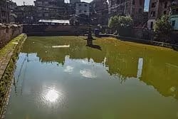
Kwathandau Pukhu
A 175-foot Malla-era pond in the Kwathandau quarter — one of the 24 *tol* neighbourhoods into which medieval Bhaktapur was divided — with a single surviving stone water spout at its northwestern corner.
- Altitude
- 1,401 m
- Coordinates
- 27.674°, 85.436°
Current Weather
Kwathandau Pukhu lies in the Kwathandau district, one of the twenty-four traditional tol (neighbourhood units) into which Bhaktapur was administratively divided during the Malla period. The area's name derives from its role as a local stronghold or fort, and the pond was part of the civic infrastructure that supported that garrison function alongside its everyday ritual use.
The tank runs east-to-west, measures roughly 175 feet long and 60 feet wide, and was laid out in the same Malla-era tradition that produced Bhaktapur's other rectangular ponds. A single dhunge-dhara — a carved stone water spout — survives at the northwestern corner; the other traditional fittings (pavilions, votive niches) have been largely lost to later rebuilding of the surrounding houses.
Though architecturally modest compared with the monumental ponds on the city's western gateway, Kwathandau Pukhu is central to understanding how the old town's water network actually functioned at the neighbourhood scale. It is a short walk from Lamuga Pukhu, Gwanga Pukhu and the Sallan Ganesh temple, and entry is free.
Location
Planning this trip? Local operators publishing trips here can arrange it.
Help us get it right
Know Kwathandau Pukhu better than we do?
We write from research and reporting, and the ground changes faster than we can keep up. If something here is out of date, or you have been and would tell it differently, we would rather hear it.